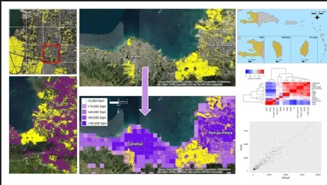
aboutOSMContentaboutOSMContentaboutOSMContent NOTE: This website is still a work in progress, please check back. aboutOSMContentaboutOSMContentaboutOSMContent NOTE: This website is still a work in progress, please check back.
Disaster Response & Humanitarian Aid

Mapping hope when it matters most.

Discover how OpenStreetMap powers global disaster relief and humanitarian efforts—saving lives through maps made by people like you.

The Map that Saves Lives

What This Means

When disaster strikes—be it a flood, earthquake, or conflict zone—response teams need accurate, up-to-date maps to reach those in need. OpenStreetMap, with its open data and global community, fills critical mapping gaps in real time. Powered by volunteers and supported by humanitarian organizations, OSM enables aid agencies to navigate chaos with clarity.

How OSM has been contributing to saving lives

Mapping as a response to the disaster in Esmeraldas, Ecuador

In response to historic floods in Esmeraldas. Ecuador’s risk management agency and HOT hubs created targeted mapping projects for flooded zones. Volunteers combined river flood-susceptibility layers with populated areas to define priority zones and then traced roads and infrastructure in OSM

Mapping as a response to the disaster in Esmeraldas, Ecuador

Haiti Earthquake Crisis Mapping (2010)

After Haiti’s 2010 earthquake, OpenStreetMap volunteers worldwide rapidly mapped roads and buildings from satellite imagery. Over 450 OpenStreetMap volunteers across the world created the a detailed map of Haiti ever, which became the basemap for relief agencies such as UN, Red Cross, World Bank, US Marines who coordinated the responseh

Haiti Earthquake Crisis Mapping (2010)

Nepal Earthquake Open Mapping (2015)

The 2015 Nepal earthquake struck Nepal on 25th April. After the earthquake, More than 7,500 OpenStreetMap contributors from around the globe collaborated to map affected areas. This crowdsourced geodata (buildings, roads, villages) supported Nepal’s government, UN agencies, and NGOs in organizing rescue logistics and relief operations during the crisis.

Nepal Earthquake Open Mapping (2015)

Hurricane Otis 2023 Response (HOT

Hurricane Otis, a formidable Category 5 storm, struck Acapulco, Guerrero, Mexico, on October 25, 2023, after this disaster, the Humanitarian OpenStreetMap Team (HOT) and community institutions initiated a project to address the critical need for accurate mapping and information. Using satellite imagery, volunteers mapped 52,000+ buildings in Acapulco in days, tagging damages to guide rescue and relief.

Hurricane Otis 2023 Response (HOT

HOT West Africa Impact Report: Mapping and Open Data Critical to Disaster Response

The Humanitarian OpenStreetMap Team (HOT) released an impact report on September 18, 2024, highlighting two years of enhancing open data for disaster response in West and Northern Africa. Key successes include vital infrastructure mapping in Morocco, Senegal, Liberia, and Nigeria, showcasing the importance of accurate data and community collaboration.

 HOT West Africa Impact Report: Mapping and Open Data Critical to Disaster Response

How you can contribute

You don't need a cape or a degree to save lives—just a mouse and a little heart .❤️

Join the HOT Tasking Manager

Help map areas in crisis and support real-time response.

Get Started

Learn mapping with LearnOSM

Step-by-step guides for beginner to expert.

Get Started

Donate to Humanitarian OSM Team (HOT)

Support mapping for disaster response worldwide.

Learn More