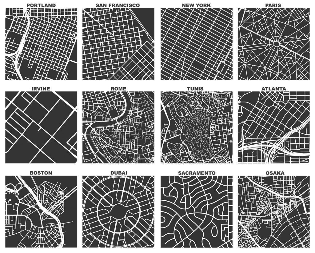
aboutOSMContentaboutOSMContentaboutOSMContent NOTE: This website is still a work in progress, please check back. aboutOSMContentaboutOSMContentaboutOSMContent NOTE: This website is still a work in progress, please check back. aboutOSMContentaboutOSMContentaboutOSMContent NOTE: This website is still a work in progress, please check back. aboutOSMContentaboutOSMContentaboutOSMContent NOTE: This website is still a work in progress, please check back. aboutOSMContentaboutOSMContentaboutOSMContent NOTE: This website is still a work in progress, please check back.
Urban Planning

Mapping the cities of tomorrow, today.

Discover how OpenStreetMap powers urban planning and city development—building better communities through maps made by people like you.

The Map that Builds Better Cities

What This Means

As urban populations surge and cities struggle to keep pace—managing housing, infrastructure, and public services under mounting pressure—planners and policymakers need accurate, ground-level geographic data to make decisions that shape lives for generations. OpenStreetMap, with its open data and global community, fills critical urban mapping gaps in fast-growing and underrepresented cities across the world. Powered by volunteers and supported by civic organizations, OSM enables urban planners, local governments, and communities to design, develop, and advocate for cities that work for everyone.

How OSM has been contributing to smarter and more inclusive urban planning

Streetlight mapping with OSM in Mexico

Humanitarian OpenStreetMap Team (HOT) documents how Mexican communities use OSM to map streetlights and urban features. By integrating mapped roads, amenities, and green spaces into GIS, planners support local development, simulate urban growth, and identify priority areas for infrastructure and public-service improvements.

Streetlight mapping with OSM in Mexico
Celine Jacquin Source link

Map Kibera: Empowering Africa’s Biggest Slum with Collective Wisdom

The Map Kibera project trained young residents of Kibera (Nairobi’s largest informal settlement) to create the first detailed map of their community on OpenStreetMap. They mapped roads, homes, clinics, water points, and even “black spots” where crimes occurred. This citizen map made Kibera visible to authorities and NGOs, one direct result was a new police post.

Long-Lasting Impact of Ramani Huria Project: A Look Back at How Community Map-Data Generated from 2015–2019 is Making a Difference for Disaster Responders in Dar es Salaam

Ramani Huria (“Open Map” in Swahili) was a World Bank-funded community mapping project (2015–2020) in Dar es Salaam, Tanzania. Local university students and residents mapped thousands of buildings, roads, and drains in flood-prone wards using OSM. These open maps have strengthened the city’s flood planning.

Long-Lasting Impact of Ramani Huria Project: A Look Back at How Community Map-Data Generated from 2015–2019 is Making a Difference for Disaster Responders in Dar es Salaam
OpenMap Development Tanzania Source link

Planning an Open Cities Mapping Project

The World Bank launched the Open Cities Project in November 2012 which used OpenStreetMap to create to create open data ecosystems that will facilitate innovative, data-driven urban planning and disaster., Open Cities has brought together stakeholders from government, donor agencies, the private sector, universities, and civil society groups to create usable information through community mapping techniques.

Planning an Open Cities Mapping Project
World Bank group Source link

How you can contribute

You don't need a cape or a degree to save lives—just a mouse and a little heart .❤️

  • Join the HOT Tasking Manager

    Help map areas in crisis and support real-time response.

    Get Started
  • Learn mapping with LearnOSM

    Step-by-step guides for beginner to expert.

    Get Started
  • Donate to Humanitarian OSM Team (HOT)

    Support mapping for disaster response worldwide.

    Learn More